SkyStef's weather page
|
|
SkyStef's weather page |
Belgian weather blog July 2010
| Date | |||
| 1 | Quite sunny but with lots of Ci (giving halo 1 and halo 2), a few Ac and tempo also a few Cu. | bl 33,0 | 30,0 |
| 2 | Starting sunny with some Ci, from noon also Cu, towards the evening Cb anvils in the west. Around 2100 tempo gusty wind of 30 kt from the west. Today, during the evening, moderate thunderstorms over provinces West- & Oost-Vlaanderen, Hainaut and the extreme southeast of Luxembourg. Warm day, stations with 34°C or more: Kleine Brogel 37,3°C, Diest 35,8°C, Beauvechain 34,9°C, Deurne 34,4°C, Liège 34,1°C, Semmerzake 34,0°C. | bl 37,3 | 33,6 |
| 3 | A light showers around 0500, afterwards quite sunny till noon. Passage of a weak thunderstorm 1300-1400, afterwards very cloudy with Ac, Sc. Breaking clouds towards sunset. Today till afternoon weak to moderate thunderstorms over all provinces except West- & Oost-Vlaanderen. One storm had temporary even a severe character (large hail) over provinces Luxembourg & Liège. | bl 33,2 | 25,8 |
| 4 | Starting very cloudy with Sc, but rapid partly cloudy with Cu, Sc, disappearing after 1800. | bl 28,9 | 25,7 |
| 5 | By the morning very cloudy with Sc, some slight rain drizzle 0900-1400. After 1500 enlarging breaks. | bl 24,0 | 23,8 |
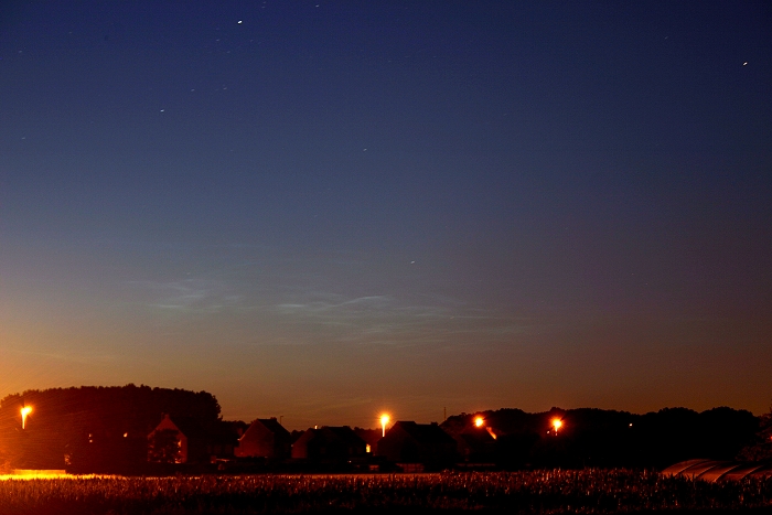
| 6 | Starting sunny with some Ci, from 0900 a few Cu, late afternoon - early evening tempo very cloudy with As later Ac. After 2300 weak noctilucent clouds visible very low (5°) above the northern horizon. | bl 25,8 | 21,8 |
| 7 | Quite sunny with some Ci, during the afternoon tempo cloudy with thin Ac. | dt 29,3 | 27,4 |
| 8 | Sunny with some Ci, afternoon tempo few Cu. | bl 33,6 | 31,3 |
| 9 | Partly cloudy, but afternoon tempo cloudy, with Ac. Between 2315-2345 some more pronounced noctilucent clouds in the NNW, around 30° above the horizon. Warm day: stations >33°C were Kleine Brogel 36,8°C, Deurne 33,9°C, Liège 33,8°C, Beauvechain 33,7°C, Zaventem 33,5°C, Ghent 33,3°C, Ukkel 33,2°C. | bl 36,8 | 33,5 |
| 10 | Starting sunny, from 1300 Ac sheets. From 1900 very cloudy with darkening skies, bit later passage of a heavy shower with moderate thunderactivity and gusts of 35kt. Was preceded by a beautiful shelf cloud. Afterwards till 2200 a couple of showers with some thunder. Total rain = 16 mm. Today, from late afternoon onwards, weak to moderate thunderstorms over all provinces (MCS exploding over the centre and north). A severe thunderstorm (supercell with possible F0 tornado) affected the north of Limbourg. According the radar images, isolated in the other provinces (except West-& Oost-Vlaanderen) large hail might have occured as well. Pictorial report to be found via this link. | bl 36,3 | 32,5 |
| 11 | Quite sunny with some Cu. Today, afternoon, over the extreme northeast of province Liège briefly a moderate thunderstorm. | bl 34,7 | .31,2 |
| 12 | Starting with sun, rapidly very cloudy with Cs, As, Ac. From 0930 briefly a shelf cloud preceding a weak thunderstorm with some rain lasting till noon = 4 mm. Large breaks with Ci, Cu, afternoon tempo some Cb' s in the NW but staying dry. Today, from morning till late afternoon (in two waves) weak to moderate thunderstorms over all provinces. some of them severe on the eastern flank of an MCS due to microbursts over the provinces Namur, Luxembourg, Liège an Limbourg. Pictorial report to be found via this link. | dt 28,4 | 26,3 |
| 13 | Partly cloudy to cloudy with Cu, Ac, Ci. | bl 30,5 | 28,0 |
| 14 | Starting sunny, from 1100 Cu, Sc. Increasing Ac from 1500. Between 1630-1700 passage of a severe thunderstorm (severe gusts of 60 kt). Afterwards some showery rain till 1830. Total 18 mm. Afterwards large breaks with Cu, Sc, Ci. Today, afternoon, severe thunderstorms (MCS) over all provinces except West- & Oost-Vlaanderen and Antwerp where some weaker ones did occur. Most damage was done due to violent winds (downburst) with Elsenborn 74 kt, Florennes 70 kt, Liège 66 kt, and Zaventem unofficial 63 kt. Also locally flooding did occur due to strong rain rate. Pictorial report to be found via this link. | bl 33,3 | 29,4 |
| 15 | Around 0130 a rain shower, around 0200 a weak thunder in the far north. Partly cloudy to cloudy with Cu Sc. Evening tempo As giving nice sunset colors. Between 2315-2345 weak noctilucent clouds very low (5°) above the northern horizon. Today, just after midnight, a few rumbles of thunder over provinces West- & Oost-Vlaanderen, Hainaut, Brabant and Antwerp. | bl 25,3 | 23,2 |
| 16 | Starting partly cloudy with Sc. From 1100 cloudy to very cloudy. some spots of rain 2000. today, early evening, some weak to moderate thunderstorms over provinces Namur, Luxembourg, Liège and Limbourg. | bl 29,2 | 25,6 |
| 17 | A couple showers in forenoon < 1 mm. Afternoon partly cloudy with Cu, evening tempo Cs. | bl 24,4 | 22,3 |
| 18 | Sunny, from noon tempo a few Cu, evening a few sheets of Ac. | bl 25,6 | 23,8 |
| 19 | Sunny, from the afternoon on some Ci fields. | bl 30,9 | 28,7 |
| 20 | Quite sunny but with lots of (thick) Ci. | bl 33,1 | 31,3 |
| 21 | Starting quite sunny with lots of Ci. From noon very cloudy with As with tempo some light rain 1400-1500 afterwards also a few drops = <1 mm. | bl 28,8 | 24,0 |
| 22 | No local weather reports till the end of the month. | bl 25,6 | 24,7 |
| 23 | bl 25,5 | 22,4 | |
| 24 | bl 24,3 | 21,7 | |
| 25 | bl 22,8 | 22,4 | |
| 26 | bl 21,8 | 21,0 | |
| 27 | fn 23,5 | 21,6 | |
| 28 | bl 25,4 | 24,2 | |
| 29 | dt 21,3 | 19,9 | |
| 30 | dt 25,5 | 24,3 | |
| 31 | cv 26,9 | 25,6 |
Note: all times are Central European Time
| Legend: TxBE (°C) = Top Tmax Belgium, TxBR (°C) = Tmax Zaventem. aw = Deurne, be = Beauvechain, bl = Kleine Brogel, br = Zaventem, bt = Beitem, ci = Charleroi, cv = Chièvres, dt = Diest, er = Ernage, fn = Koksijde, fs = Florennes, gh = Ghent, lb = Elsenborn, lg = Bièrset, mr = Mont-Rigi, os = Ostend, sh = Saint-Hubert, sp = Spa, sz = Semmerzake, uk = Ukkel. |