| Weather pictures & report of August 23 2011 |
| MCS thunderstorms along thermal troughs |
| Synopsis: at 500 hPa, east of a relaxing trough west of the British Isles, our area in a moderate SW'ly flow of warm and humid potentially unstable air. During the morning passage of the axis of a short wave upper trough. At surface a small depression over northwest France moving into the channel with related to it the passage of of several thermal trough lines triggering thundery showers. Especially central parts of Belgium were affected with local flooding. The consecutive passage of no less than four big multicell thunderstorms (of which 3 MCS) resulted in the highest amount of discharges of the entire summer season over Belgium, namely 87000. All pictures taken at Kampenhout (central Belgium) with hours in local time (CET). |
 |
|
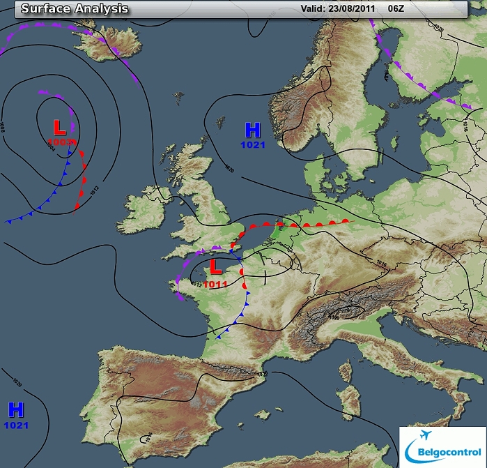
Surface analysis of August 23 2011 at 0800 CET. Related to a depression
over northwestern France, a thermal trough crossing Belgium during the
morning - early forenoon. (Source chart: Belgocontrol)
|
|
Loop of 18 surface analyses of each hour starting from August 22 at 2300 CET with
weather plots showing the thundery outbreaks in 4 waves. (Source: meteocentre.com)
|
 |
|
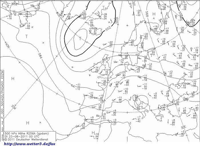
Upper air analysis 500 hPa of August 23 2011 at 0200 CET. A relaxing
upper trough west of Ireland as extension of the cold pool just south of Iceland
with furthermore a relaxing shortwave trough over western France which
crossed Belgium in the forenoon. On the eastern flank a ridge near Italy
- Balkan. It resulted
over our area in a moderate SW'ly flow. (Source chart: DWD via wetter3)
|
 |
|
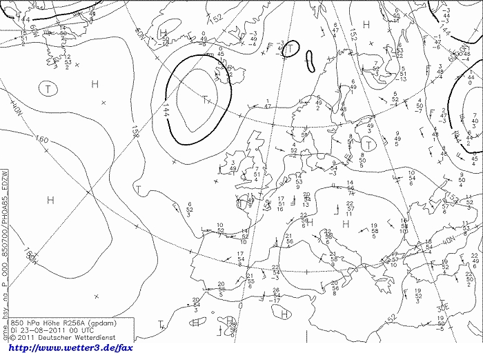
Upper air analysis 850 hPa of August 23 2011 at 0200 CET. Between the
low near Iceland and anticyclone over the Balkan, our area in a weak to
moderate S'ly flow of warm air. (Source chart: DWD via wetter3)
|
 |
|
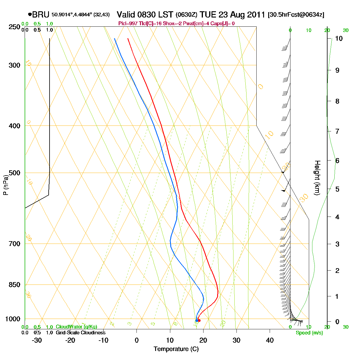
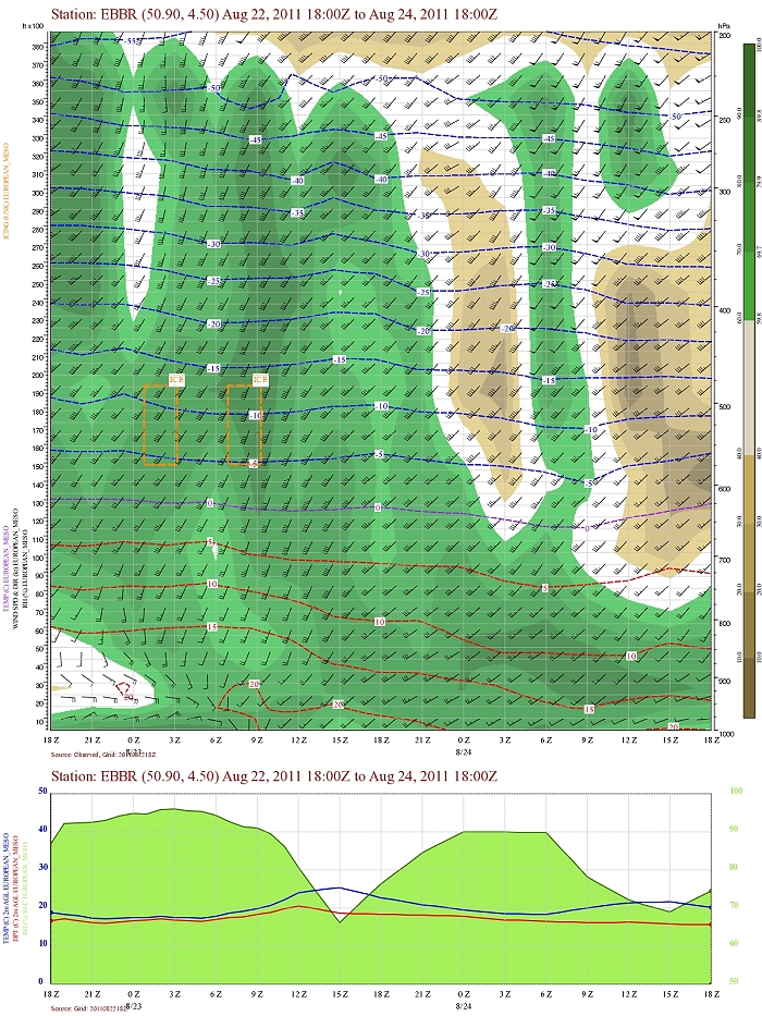
Loop of forecasted soundings for Brussels of August 23 2011 between
0830-2000 CET. During the morning hours a so called CAP (or inversion) was
present below 3000ft. Nevertheless due to passage of some thermal
troughlines instability was released in form of MCS thunderstorms during
the previous
night and morning - forenoon. Due to diurnal heating the CAP was cleared in the
afternoon,
but by then it turned out too dry in the upper levels to form deep
showers. Also
detectable before noon is a pronounced directional windshear in the lowest 3 km
whereby supercells could not be excluded. (Source: RASP)
|
|
Another loop of forecasted soundings for a 15 hours period (in steps of
three hours) of Brussels from August 23 2011, 0500 CET onwards. Included
are some thunderstorms indices: surface based CAPE was during the night
0 J/kg, but the most unstable one went up to around 1000 J/kg (which
could be released
with a trigger), KI 35, TT 55,
LI -5 = strong convective potential which may lead to frequent
thunderstorms, isolated severe. Directional shear was moderate with 127
m²/s², low level shear was 25 kt, deep layer shear 35-40 kt. Due to the
moderate CAPE and moderate shear, multicells (eventually MCS) and
supercells could be expected. (Source: weatheronline.co.uk).
|
 |
|
Forecasted vertical profile and surface temperature for Brussels Airport of August 22 from 2000 CET and the following 48 hours. Legend of upper map: green-brown-white
is humidity in steps of 10% with darkest green being 90% or more, wind
in kt, temperatures each 5°C. Humid air at the begin of the period well towards the
upper levels (200 hPa). Furthermore a slight fall of the upper air
temperatures in the morning with passage of short wave upper trough,
repeated during the evening with passage of cold front, and much drier air behind
(above 13000 ft). Also clearly detectable is a rather strong wind shear
first 12-15 hours in the lowest 6000ft. (Source: Belgocontrol)
|
 |
|
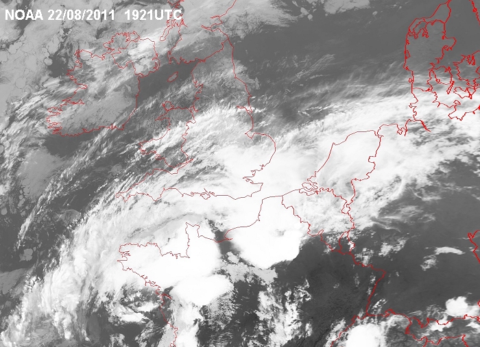
Satellite image of 22/08/2011 at 2121 CET in the infra-red channel with
the formation of
some big multi-cells over western and northwestern France. The first one
entered western parts of Belgium just after midnight. (Source sat
picture: NOAA and University of Bern)
|
 |
|
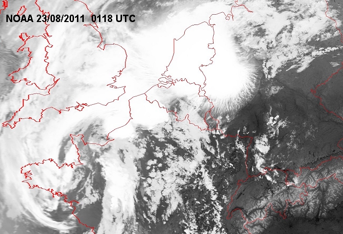
Satellite image of 23/08/2011 at 0318 CET in the infra-red channel with
the first MCS now over Holland, but more cells on its way to Belgium. (Source sat
picture: NOAA and University of Bern)
|
|
23/08/2011 0315-0700 CET. Satellite loop in the infra-red channel.
Three multi-cell thunderstorms (of which two MCS) over Benelux and surrounding area. (Source sat
picture: Eumetsat via Sat24.com)
|
|
23/08/2011 0615-0745 CET. Satellite loop in the visual channel. A
developing MCS thunderstorm affecting western parts Belgium. (Source sat
picture: Eumetsat via Sat24.com)
|
|
23/08/2011 0815-1315 CET. Satellite loop in the visual channel. This MCS thunderstorm
migrated further northeastwards with still some new but smaller cells building behind. (Source sat
picture: Eumetsat via Sat24.com)
|
Radar loop (rain fall rate in mm) of August 23 2011 between 0315-1335 CET. Mainly the central parts of Belgium were affected by a lot of rain and lightning with the passage of no less than 4 multi-cell (MCS) thunderstorms. (Source radar picture: Belgocontrol)
|
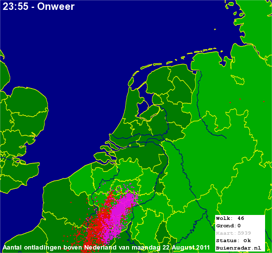 |
Corresponding discharges of August 22 2011 from late evening onwards a first multi-cell reaching provinces Hainaut, Namur and Brabant-Walloon . (Source lightning picture: Buienradar)
|
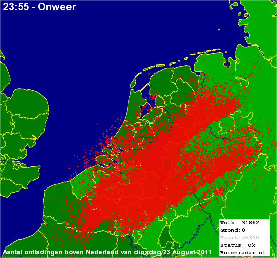 |
Corresponding discharges of August 23 2011 with mainly the central & northeastern parts of Belgium and southeastern parts of Holland being affected by a lot of discharges during the first 1200 hours of the day. Total discharges of all storms was 87000 with around 12000 cloud-to-ground strikes. (Source lightning picture: Buienradar)
|
 |
|
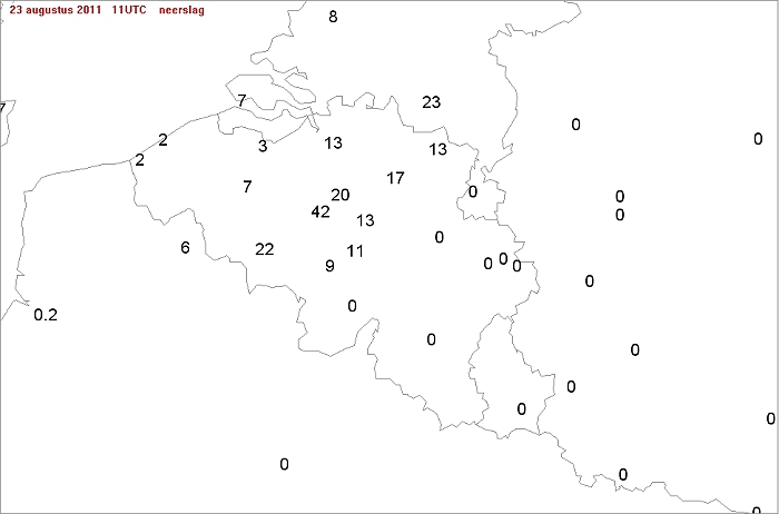
Main theme (besides the amount of lightning strikes) was the massive rain fall: Ukkel was the top with 42 mm, followed by Zaventem with 20 mm. My
location at Kampenhout (5 km northeast of Zaventem) received 33 mm.
|
Metars of Brussels Airport (EBBR) (hours in UTC). Translation: copy
paste each obs via
metar-decoder
EBBR 222120Z 06005KT 040V100 7000 TS FEW035CB 17/15 Q1017 TEMPO
VRB15G30KT 3000 TSRA=
|
 |
|
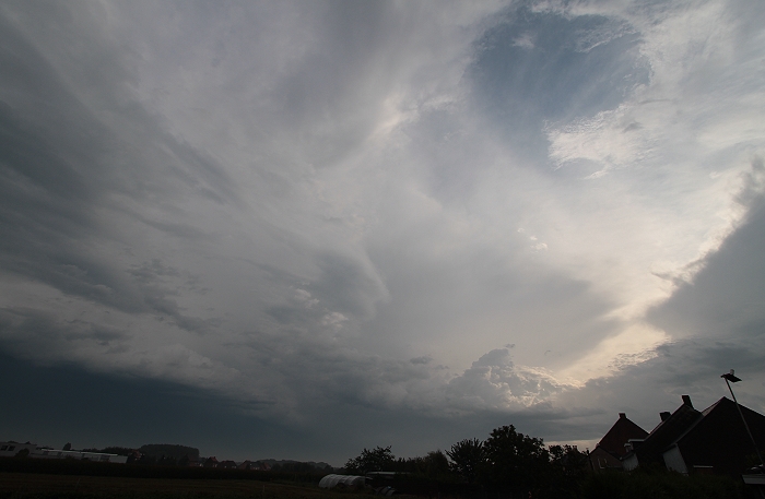
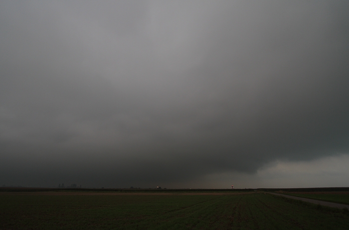
23/08/2011 0854 NE. When the third thunderstorm (second MCS) moved towards the east edging my
location, a typical chaotic sky belonging to a thundery weather was left
behind.
|
 |
|
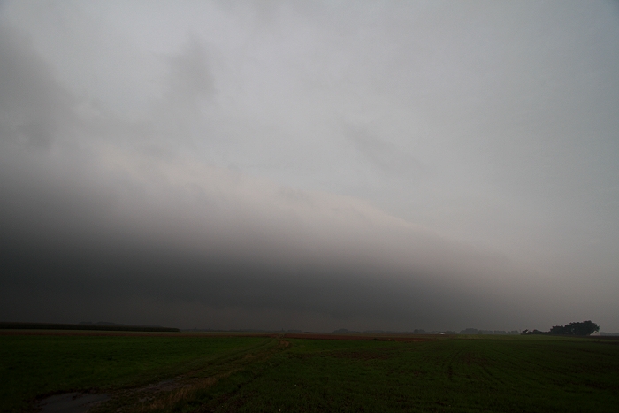
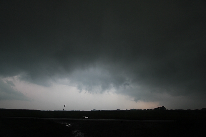
23/08/2011 0954 W. When the fourth (and final) thunderstorm (third MCS) moved in it was
preceded by a low rapid moving rolling cloud.
|
 |
|
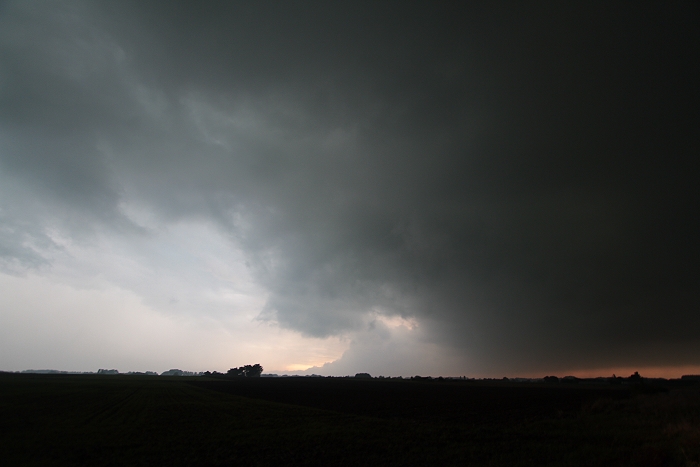
23/08/2011 0955 W. Wider view, sadly visibility was not that great and
when approaching some cloud fragments in front of the roll began to
form.
|
 |
|
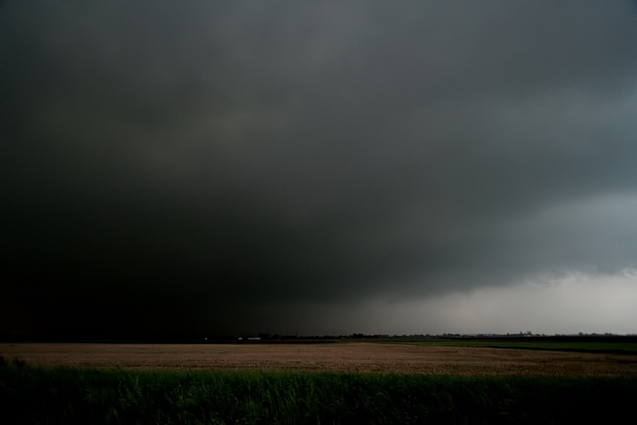
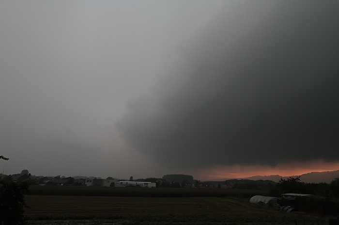
23/08/2011 0957 SW. View bit to the south when the roll cloud was almost
overhead with very dark skies.
|
 |
|
23/08/2011 1000 NNW. Roll cloud overhead.
|
 |
|
23/08/2011 1002 N. Roll cloud overhead.
|
 |
|
23/08/2011 1003 S. Opposite side where the sky was on its darkest.
|
 |
|
23/08/2011 1012 N. Backside of the roll cloud.
|
|
The roll cloud with below very the dark skies was between 0954-1001 also captured on film
and speeded up to 18 frames per
second.
|