| Weather pictures & report of May 25-26 2009 |
| Large multi-cell (MCS) & supercell thunderstorms ahead and along convergence line. |
| Synopsis: at 500 hPa initially a cut-off low north of Spain and a relaxing upper trough west of Eire, amalgamating and its axis crossing Belgium during the night of May 26-27. Ahead advection of warm and humid (Tw 850 hPa up to 17°C), potentially deep unstable air from SSW with also a convergence line within a shallow thermal low which crossed Belgium during the night of May 25-26. During the daylight period of May 25, a long living MCS affected the Ardennes, the next night a supercell and MCS affected the west and center of Belgium. A few pics of lightning were made at Steenokkerzeel, hours in local time. |
 |
|
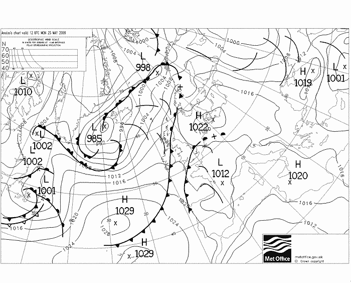
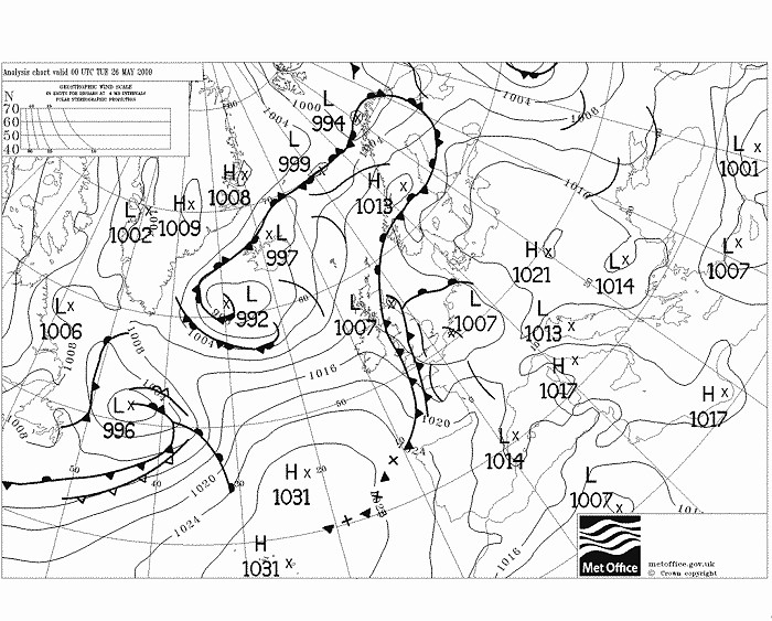
Surface analysis of May 25 at 1400 CET. An incoming thermal low over the
south of France, a retreating high near Denmark. The black line over south of
Belgium concerned an MCS.
(Source chart: Met Office - UKMO)
|
 |
|
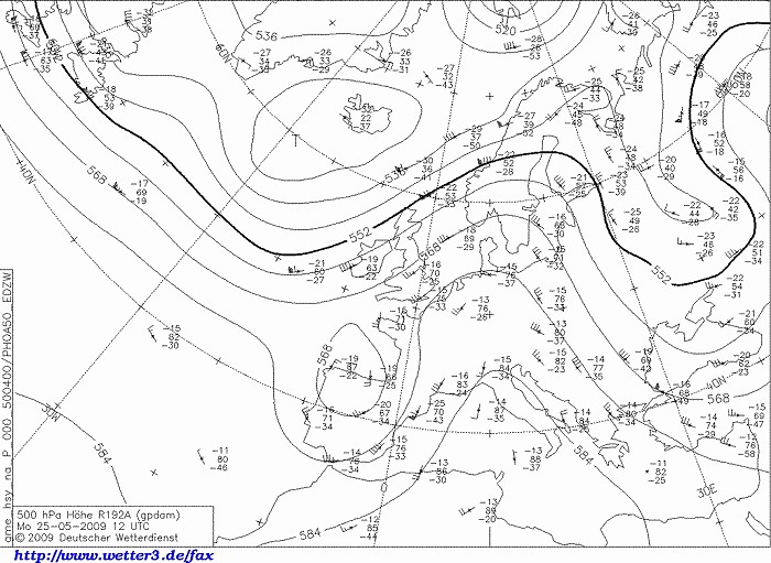
Upper air analysis 500 hPa of May 25 at 1400 CET. Approaching cut-off low north
of Spain & trough west of Eire and a ridge over Germany slowly moving eastwards. (Source chart: DWD via wetter3)
|
 |
|
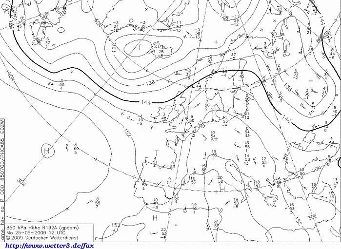
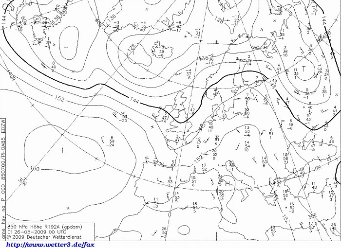
Upper air analysis 850 hPa of May 25 at 1400 CET. Very warm air
present over western parts of central Europe with temperatures around
15°C, bit more to the west only 9°C, so quite a sharp contrast. (Source chart: DWD via wetter3)
|
25/05/2009 1015-2130 CET. Satellite loop in the visual channel. MCS reactivating over the Ardennes, by the evening some smaller cells arrived over the extreme west of Belgium. (Source sat picture: Eumetsat via Sat24.com)
|
 |
|
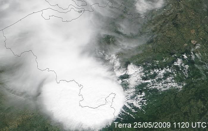
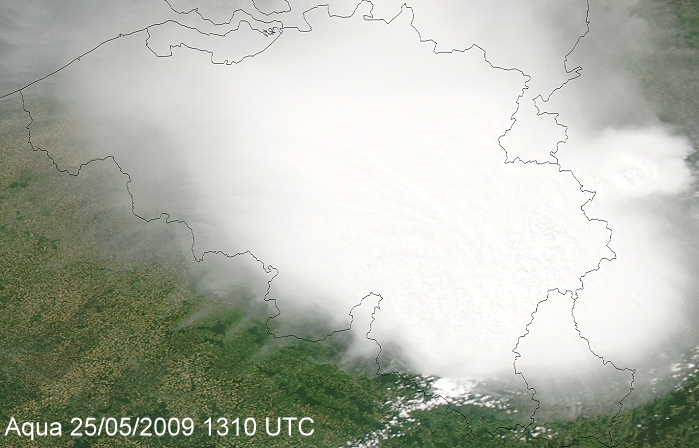
25/05/2009. Satellite picture taken around 1320 CET (visual channel). It
shows a detail of the exploding MCS over the southwest of the Ardennes. (Source:
Image courtesy of MODIS Rapid Response Project at NASA/GSFC)
|
 |
|
25/05/2009. Satellite picture taken around 1510 CET (visual channel).
Couple hours later, the MCS spread out its cloud shield over entire
Belgium. However the active part was situated over the northwest of
province Luxembourg and south of province Liège, while the rest
encountered some high and medium level cloudiness with locally a few
drops of rain (Source: Image courtesy of MODIS Rapid
Response Project at NASA/GSFC)
|
 |
|
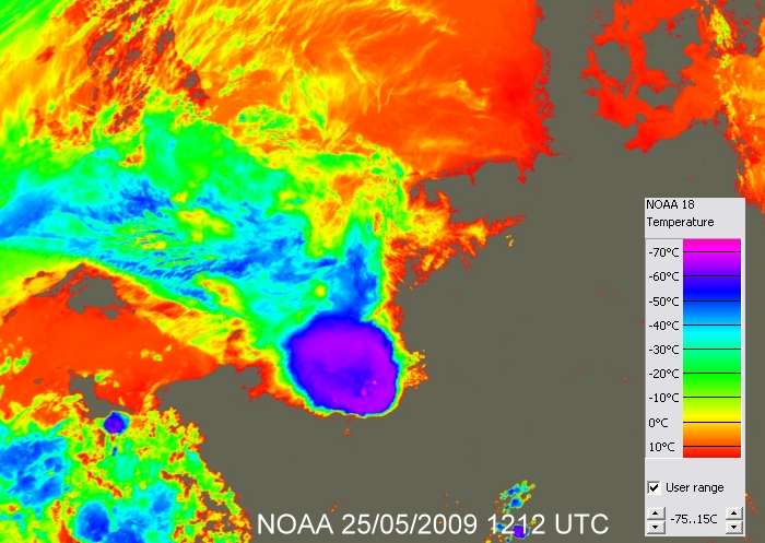
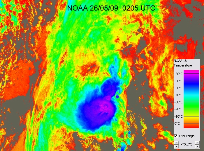
25/05/2009. Satellite picture taken around 1412 CET (infra-red channel
with temperature scale). It shows the MCS over the Ardennes with on the
southeastern side two overshooting tops with temperatures close to
-70°C. (Source: NOAA)
|
Radar loop between 1235-2130 CET. Precipitation tops went up to around 15 km. The cell over the Ardennes produced locally hailstones with a diameter of 4 cm. Observations on some official weather stations showed at St-Hubert a gust of 37 kt, and at Mont-Rigi 9 mm rainfall. (Source radar picture: Belgocontrol)
|
Loop of discharges reaching Earth's surface between 1200-2200 CET. (Source picture: Blids)
|
 |
|
Surface analysis of May 26 at 0200 CET. Thermal low with trough (black
line) over the
west of Belgium.(Source chart: Met Office - UKMO)
|
 |
|
Upper air analysis 850 hPa of May 26 at 0200 CET. Cooler air started to
invade Belgium. (Source chart: DWD via wetter3)
|
 |
|
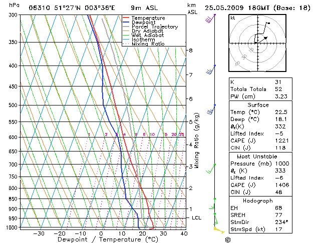
Forecasted sounding of Vlissingen May 25 at 2000 CET. A deep potential unstable
layer above 850 hPa, which clearly needed a trigger for ignition. Due to
the nightly cooling, lift must come from dynamical processes like the
passage of a thermal low or through
and indeed both came along. Here ahead of these features with in the
lowest levels still weak easterly winds, but starting from 850 hPa
veering to SW and increasing in speed. (Source picture: weeronline)
|
 |
|
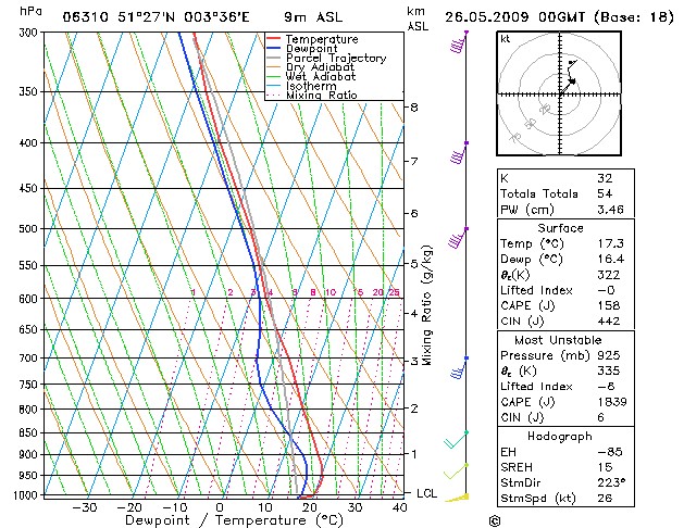
Forecasted sounding of Vlissingen May 26 at 0200 CET. Even a bit more unstable
now as indicated by a slightly larger amount of most unstable CAPE, now
reaching almost 2000 J/kg. If showers would form these would be the big
ones in form of MCS type. Above all the shear (in
speed and velocity) increased as well. With a forecasted helicity in a
small area over western Belgium temporary up to 250 m²/s² (no clear
indication on these progtemps), low level shear 0-3 km tempo up to 30 kt,
deep layer shear 0-6 km up to 40 kt, there was even a chance of having supercells
(with tornado) or bowecho. (Source picture: wofrance)
|
 |
|
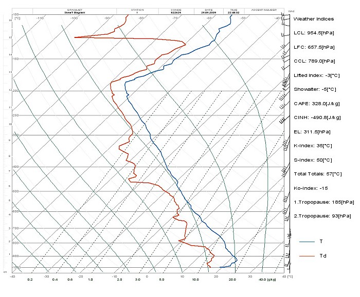
Observed sounding of Beauvechain May 26 around 0100 CET. The real state
of the atmosphere showed that the calculated progtemps were quite good.
Below 925 hPa, a rather strong inversion, above a deep unstable layer up to tropopause
which was situated
at 185 hPa corresponding with a height of 12,5 km. Air remained even saturated above the tropopause and this up to
a height of 15 km, the
result of spreading out Cirrus of overshooting tops. On the right
some interesting values like the thunderstorm indices. (Source picture: Belgocontrol)
|
 |
|
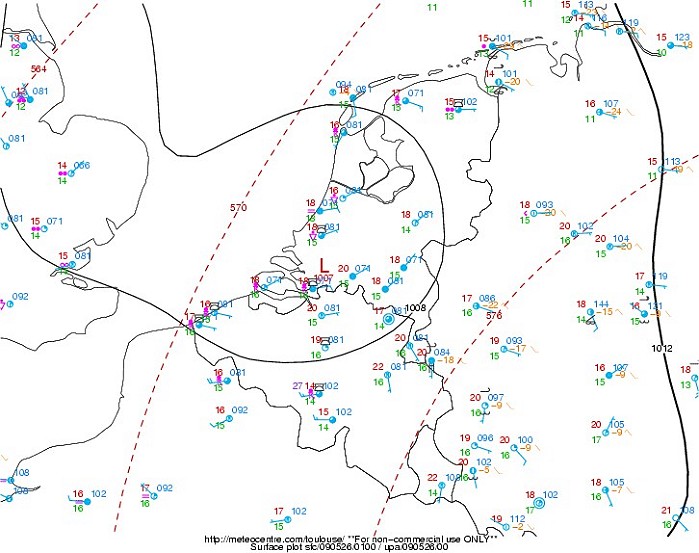
Mean sea level pressure map including the weather plots of 0300 CET.
Around that time the squall-line passed Brussels, indicating the thermal low situated of over the
south of Holland. (Source map: Meteocentre).
|
26/05/2009 0115-0400 CET. Satellite loop in the infra-red channel. Initially three MCS thunderstorms over the Benelux amalgamating to one big one. (Source sat picture: Eumetsat via Sat24.com)
|
 |
|
26/05/2009. Satellite picture taken around 0405 CET (infra-red channel
with temperature scale). It shows that the core of the MCS was at that
time located over the mid Netherlands. (Source: NOAA)
|
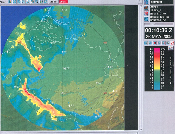
Radar sequence between 2130-0555 CET. Again precipitation tops went up to 15 km. Around 0000 UTC, the cell over Hainaut & Oost-Vlaanderen was a supercell producing hailstones with diameter between 4 and 10 cm. It was later taken over by a very fast moving squall-line speeding up to around 55 kt. At 0100 UTC, the radar encountered briefly the severe precipitation belt of the squall-line, as result loosing even "its sight". (Source radar picture: Belgocontrol)
|
 |
|
26/05/2009 0210 CET. The cell over Oost-Vlaanderen shows signs of a
hook echo. Closer inspection of the radar images reveals that most of
the time no real hook echo form was present, but a so-called "pendant
echo" form. This could be related to a variant of a supercell, namely a
so-called "hybrid supercell-multicell". This type of cell is most
effective in producing very large hail and presumable such cell was
responsible for some impressive sized hailstones on its entire track.
Just before entering Belgium even
hailstones with a diameter of 12 cm were measured in
Raillencourt-Sainte-Olle (northern France). (Source picture: Belgocontrol).
|
 |
|
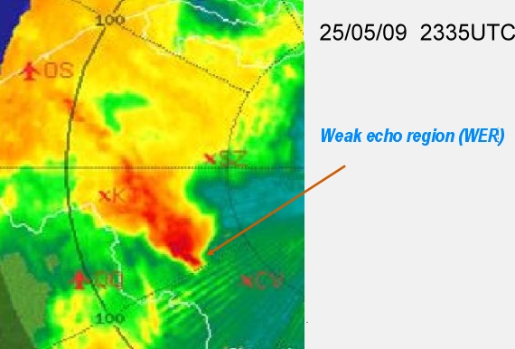
26/05/2009 0135 CET. Zooming in on the
pendant shape echo we can discover a weak echo region, an area where the
inflow and updraft causes less intense precipitation reflectivity (Source picture: Belgocontrol).
|
 |
|
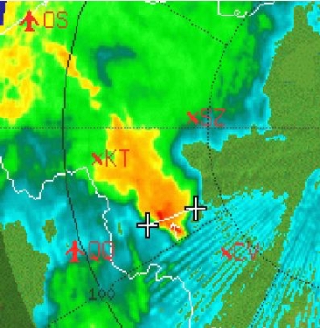
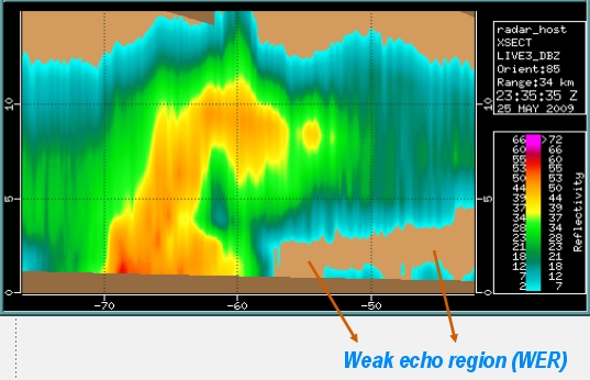
26/05/2009 0135 CET. Making a vertical
cut
between the two plus signs (Source picture: Belgocontrol).
|
 |
|
26/05/2009 0135 CET. Shows the weak echo
region where the inflow is quite strong and no precipitation falls to the ground (Source picture: Belgocontrol).
|
 |
|
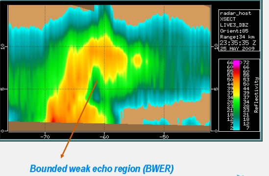
26/05/2009 0135 CET. And also a bounded
weak echo region
where the updraft is quite strong with high reflectivity (possible hail) trailing well above the ground level (Source picture: Belgocontrol).
|
 |
|
Hail with the largest diameter did fall in the extreme northwest of province
Antwerp, namely in a place called Verrebroek. According the radar images
did occur around 0305 CET. Measurements on the field, and this after a
while and thus some melting could take place, it still came out to an
impressive 9,2 cm. Prevailing form
of the large stones were typical
squeezed ball-ellipsoid or so-called
"oblate". (Source picture: VRT
library).
|
 |
|
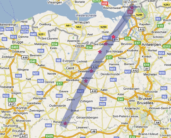
Hail trajectory with the red stars being reports on the field of stones
of at least 4 cm diameter. The brightest red star is situated in
Verrebroek. (Source: weerwoord).
|
 |
|
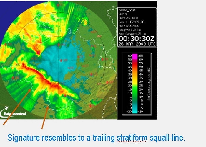
26/05/2009 0230 CET.
The squall line that affected the center of Belgium in detail, it later
evolved to a a bow echo (Source picture: Belgocontrol).
|
 |
|
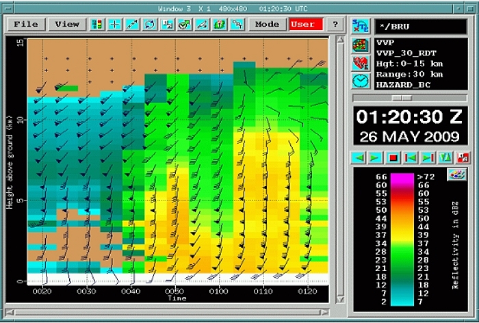
26/05/2009.
Windprofiler between 0220-0320 CET up to 15 km shows
remarkable strong winds of 50 kt at 4 km height (Source picture: Belgocontrol).
|
 |
|
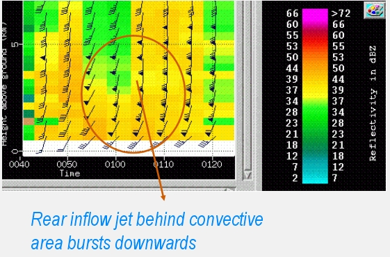
26/05/2009.
And these strong winds reached the surface around 0300 CET as downburst
of the rear inflow jet (Source picture: Belgocontrol).
|
 |
|
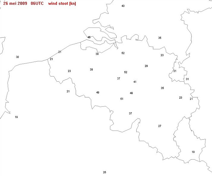
26/05/2009. Map of the wind gust (in kt) which occurred between 0200-0800 hr.
The gusts over central parts of Belgium were linked to the squall-line.
On one of the wind meters at Brussels Airport (located Steenokkerzeel) a
gust of 58 kt was observed.
|
 |
|
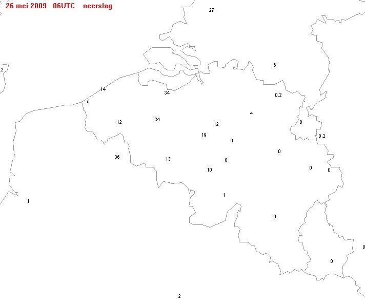
26/05/2009. Map of total precipitation (in mm) between 0200-0800 hr. A small area over Oost-Vlaanderen had the most of it as two heavy thundery showers passed
by. Over the center of Belgium, the squall moved
that fast, that no big amounts did fall.
|
Loop of discharges reaching Earth's surface between 2200-0415 CET. Around 30000 strikes were measured by the Belgian SAFIR, of which around half of it cloud-to-ground strokes. (Source picture: Blids)
|
Some metars (hours in UTC) of Florennes (EBFS), Charleroi (EBCI), Brussels (EBBR), Antwerp (EBAW) and Woensdrecht (EHWO) in Holland. Especially the station in the Netherlands gave some detailed info how things were during the passage of the squall line. Since 2009 no special reports anymore for the Belgian stations, so some luck in needed (like EBAW) to get a clue about the force of this storm.
EBAW 252250Z AUTO 03007KT CAVOK 20/15 Q1009
EBAW 252220Z AUTO 04007KT CAVOK 20/15 Q1009
Below screenshots of some meteo parameters measured at Brussels Airport
during the passage of the squall-line. |
 |
|
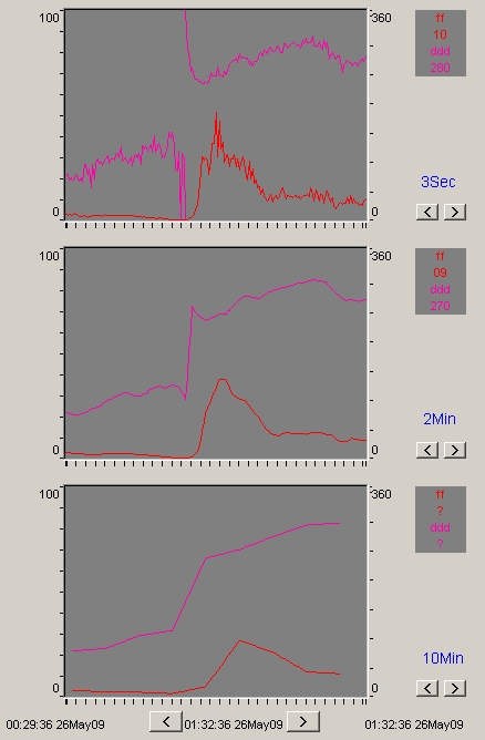
Brussels Airport observations of the wind at runway 25L. Speed in kt
(red) and direction in degrees (pink), every 3 seconds (on top), 2
minutes (middle), 10 minutes (bottom). At 00:56:00 the 3 seconds wind
was 120 degrees 01 kt, next minute veering to 240 with from 00:57:54
onwards speed exceeding 20 kt, from 00:58:12 exceeding 30 kt, from
01:00:27 topping 40 kt, tempo decreasing to 30 kt, but between 01:01:12
and 01:01:15 topping to 53 kt, from 01:02:24 on decreasing below
40 kt, from 01:05:00 below 30 kt. Not depicted:
|
 |
|
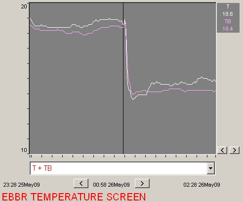
Brussels Airport observations of the temperature (°C), at 1,5 m (white)
and surface (pink) revealing a remarkable drop of more than 6°C within
minutes.
|
 |
|
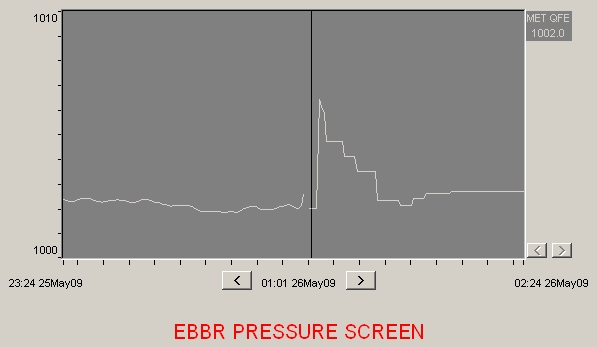
Brussels Airport observations of mean sea level pressure (hPa), perhaps
even more remarkable with a rise of 4,4 hPa.
|
 |
|
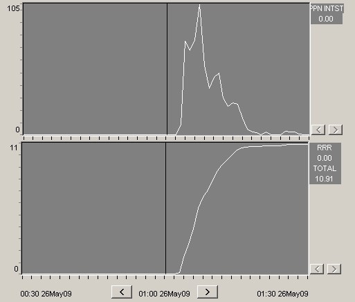
Brussels Airport observations of the precipitation (mm), intensity (on
top) and total amount (bottom). The rain rate peaked above 100 mm/h, but
it lasted around 4 minutes, afterwards rate decreased. Total amount of
rain was 12 mm.
|
To summarize things, this quite fascinating satellite loop between May 24 1415 CET and May 26 1345 CET (infra-red channel enhanced with color to accentuate the coldest spots). It shows the long living and very interesting cell which affected the Ardennes with an unpredictable track. Furthermore the exploding MCS over France & the Benelux area (Source: Meteosat via K. Hamid).
|
 |
|
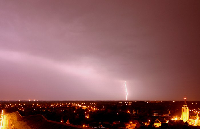
26/05/2009 0344 NNE. When most of the precipitation on the
backside of the squall-line was cleared, a couple pictures of discharges (all CG's)
could be made. This strike was at approx 40 km.
|
 |
|
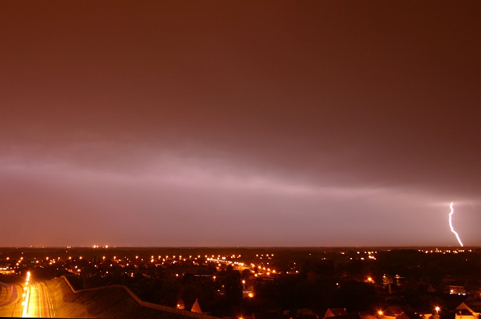
26/05/2009 0353 NNE. The best shot, distance of this long vertical
discharge was between 15-20 km, with its impact at 20 km, location was
Puurs
just northwest of Mechelen.
|
 |
|
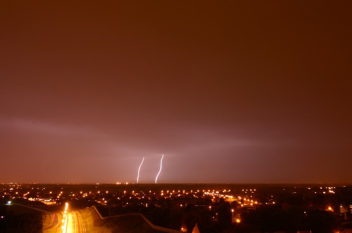
26/05/2009 0357 NNE. Discharge at approx 75 km.
|
 |
|
26/05/2009 0400 NNE. Discharge at approx 75 km.
|