Today's high T
at
14:32
17.7°C
Today's low T
at 3:13
9.0°C
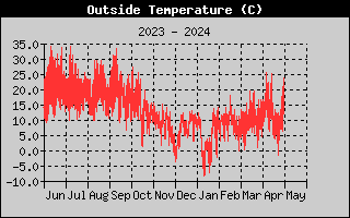
Yearly high T
30.7°C
Yearly low T
-5.7°C
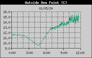
Today's high Td
at
14:29
8.9°C
Today's low Td
at 3:06
5.0°C
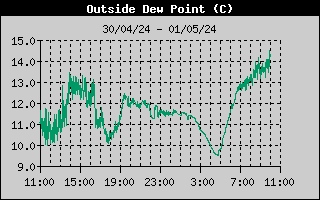
Yearly high Td
14.4°C
Yearly low Td
-8.3°C
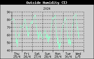
Today's high humidity
at
3:28
78%
Today's low humidity
at 14:15
53%
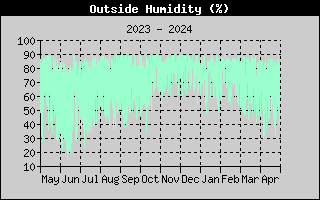
Yearly high humidity
91%
Yearly low humidity 18%
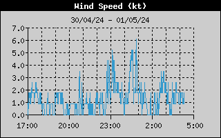
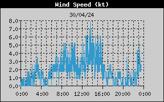
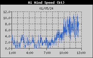
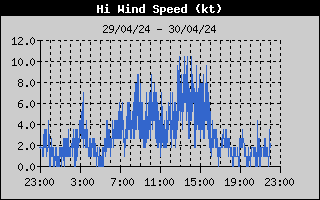
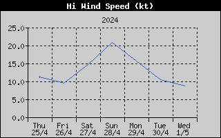
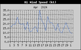
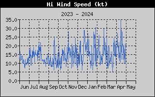
Wind speed
1.7 kt
1' average speed
2.7 kt
max 4.3 kt
2' average speed
2.2 kt
max 4.3 kt
5' average speed 2.7 kt
max 7.0 kt
10' average speed
3.0 kt
max 8.7 kt
Today's max gust
at 4:23
12.2 kt
Yearly max gust
162.6 kt
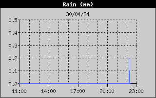
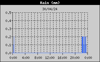
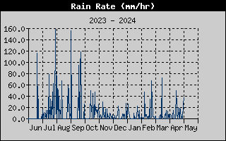
Today's rain
0.0 mm
Storm rain
0.0 mm
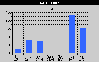
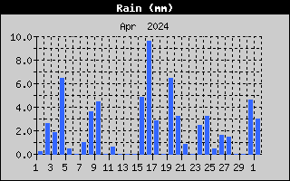
Monthly rain
1.4 mm
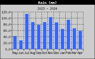
Yearly rain
177.6 mm
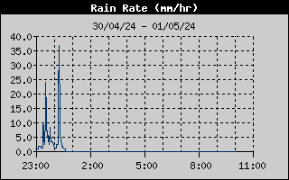
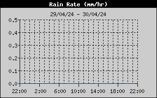
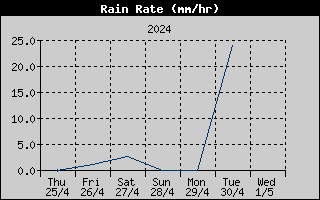
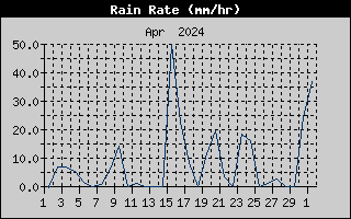
Rain rate
0.0 mm/hr
High rain rate
0.0 mm/hr at ----
High hourly rain rate
0.0 mm/hr
High monthly rain rate
2.4 mm/hr
High yearly rain rate
155.6 mm/hr
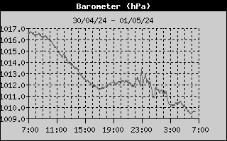
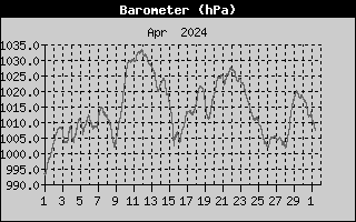
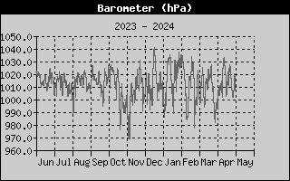
Today's high pressure
at
13:23
1021.2 hPa
Today's low pressure
at 5:04
1019.2 hPa
Yearly high pressure 1043.7 hPa
Yearly low
pressure
980.2 hPa
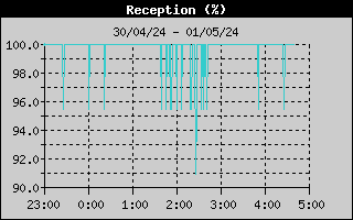
Station reception status last 6 hours
Legend
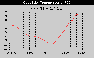
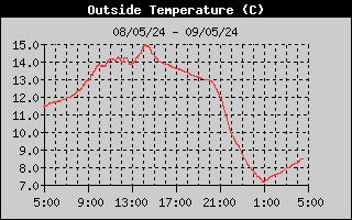
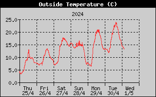
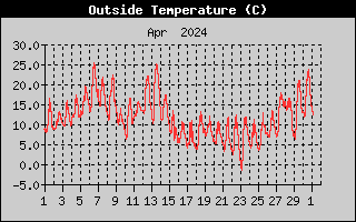
Outside Temperature
Is the air temperature
measured at 1,5 meters height measured in degrees Celcius. A solar powered fan runs 24 hours/day
avoiding as much as possible greenhouse effects
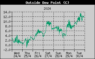
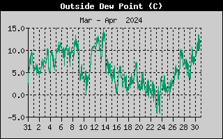
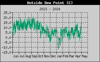
Outside Dew Point
Is the temperature
(in degrees Celcius) at which condensation
forms (=100% relative humidity)
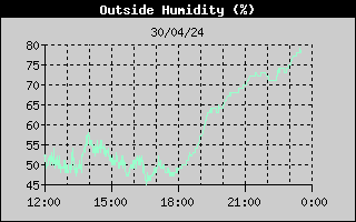
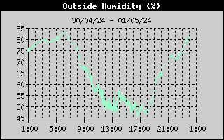
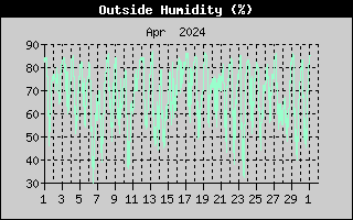
Outside Humidity
Relative humidity in % is the
ratio of the air's water vapor content to its capacity. Completely
saturated = 100%
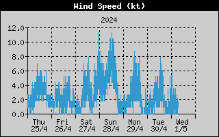
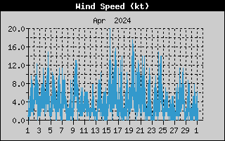
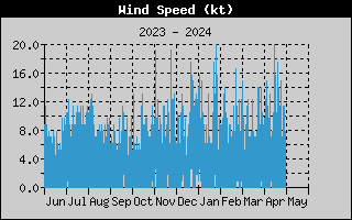
Wind Speed
Wind speed in knots measured at 10
meters height. The graphs shows the 1 minute average speed with highest
gust in this period. In the table also 2, 5, 10 minute average wind
speed are shown with corresponding gusts in their periods.
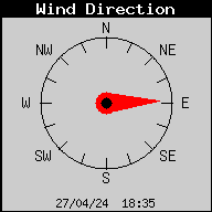
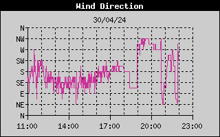
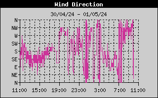
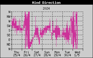
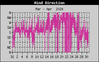
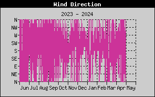
Wind Direction
Wind direction where the wind blows
from at 10 meters height. The graphs show the 1 minute average
direction.
Wind Chill
Measured in degrees Celcius, is the combination of temperature and
wind speed. When the wind is blowing, it carries away the air that
has been warmed by your body. It feels as if the temperature is
lower than it really is. Above
33°C, wind movement has no effect on the apparent temperature, so
wind chill is the same as the outside temperature.
Heat Index
Measured in degrees Celcius, uses
the temperature and the relative humidity to determine how hot the
air actually 'feels'. When humidity is low, the apparent temperature
will be lower than the air temperature, since perspiration
evaporates rapidly to cool the body. However, when humidity is high
(i.e., the air is saturated with water vapor) the apparent
temperature 'feels' higher than the actual air temperature, because
perspiration evaporates more slowly. The heat index is only measured
when the air temperature is above 14°C because it is insignificant
at lower air temperatures. (Below 14°C, heat index = air
temperature).
THW Index
THW (Temperature -
Humidity - Wind) Index uses humidity, temperature and wind to calculate an
apparent temperature (in degrees Celcius).
Rain
Four separate readings for tracking
measured in mm:
storm rain, daily rain, monthly
rain and yearly rain. Storm rain is the amount of rain in a
continuous period of rain with an amount of leeway for beginning and
end. As used here, storm begins when 0.5 mm of rain has fallen in a
24-hour period, and continues until 24 hours pass without 0.5 mm of
rain.
Rain Rate
Is calculated
by measuring the interval of time
between each 0.2 mm rainfall increment, the minimal amount of rain
for tipping the bucket mechanism.
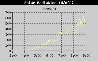
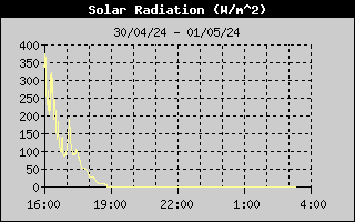
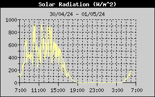
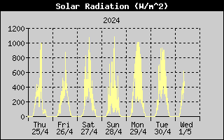
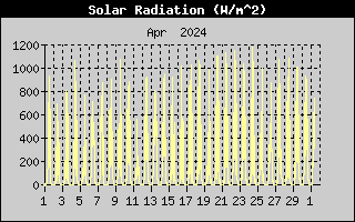
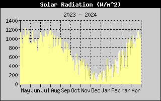
Solar radiation
What we call 'current
solar radiation' is technically known as Global Solar Radiation, a
measure of the intensity of the sun's radiation reaching a
horizontal surface. This irradiance includes both the direct
component from the sun and the reflected component from the rest of
the sky. The solar radiation reading gives a measure of the amount
of solar radiation hitting the solar radiation sensor at any given
time, expressed in Watts per square meter (W/m²). Bright sunshine is
considered to be occurring when the solar radiation level exceeds
100 W/m², so it can easily be worked out how many hours of sunshine
occur daily from this reading.
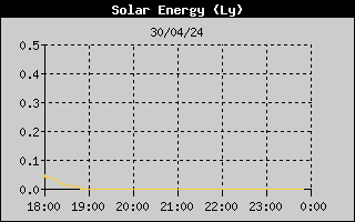
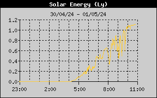
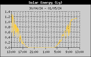
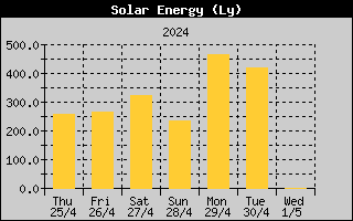
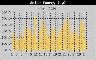
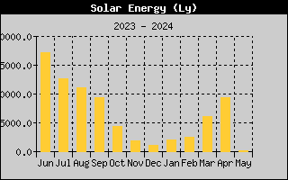
Solar energy
The energy transmitted from the sun
in form of electromagnetic radiation, measured in langleys (Ly). One
langley is equal to one gram-calorie per square centimeter. A
gram-calorie is the amount of heat required to raise the temperature
of one gram of water one degree Celsius.
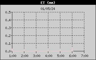
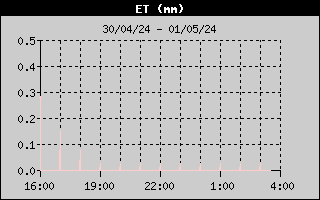
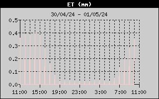
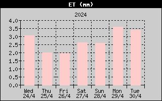
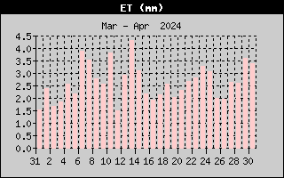
ET (evapotranspiration)
Measured in mm, is the amount of water transferred from
the earth to the atmosphere due to the combined effects of
evaporation and transpiration. Transpiration is the process by which
plants release water vapor into the air.
The Davis Vantage Pro Plus uses air
temperature, relative humidity, average wind speed, and solar
radiation data to estimate ET.
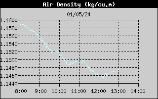
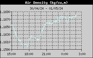
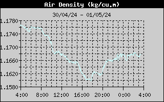
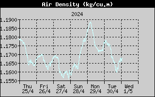
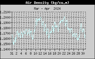
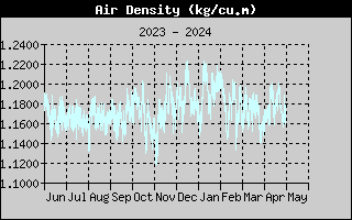
Air Density
The Davis Vantage Pro2
measures the air density in kilogram per cubic meter by taking
account of the air temperature, pressure and how much water vapor is
in the air. We know that one cubic meter of air contains around 78%
nitrogen molecules, with an atomic weight of 28. Another 21% of the
air is oxygen, with the molecules having an atomic weight of 32. The
last 1% is a mixture of other gases, which are insignificant. Other
molecules are free to move in and out of our cubic meter of air. If
water vapor molecules are added to our cubic meter of air, nitrogen
and oxygen molecules will leave, the total number of molecules in
our cubic meter of air staying the same. As the water molecules have
an atomic weight of 18, (lighter than nitrogen and oxygen), the
weight of our cubic meter decreases, thus the density decreases. We
can only get a calculation for air density in the outside
temperature is above freezing point.
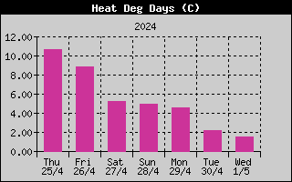
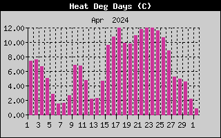
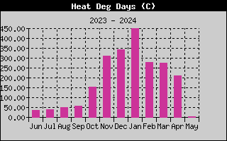
Heat deg days
Heating degree days (HDD)
are used to estimate the amount of energy required for residential
space heating during the cool season. To calculate the HDDs you must
first find the mean temperature for the day. This is usually done by
taking the high and low temperature for the day, adding them
together and dividing by two. If the mean temperature is at or above
18.3°C, then the HDD amount is zero. If the mean temperature is
below 18.3°C, then the HDD amount equals 18.3°C minus the mean
temperature. For example, if the mean temperature was 8.0°C then
the HDD amount equals 10.3 °C. Normally
there will no readings during the spring and summer, unless a
particularly cold day may occur.
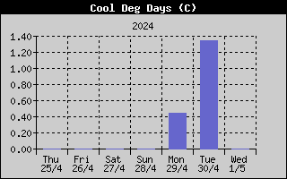
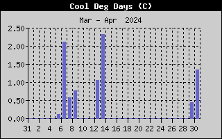
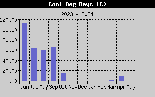
Cool deg days
Cooling degree days (CDD)
are used to estimate the amount of air conditioning usage during the
warm season. To calculate CDDs, you must first find the mean
temperature for the day. This is usually done by taking the high and
low temperature for the day, adding them together and dividing by
two. If the mean temperature is at or below 18.3°C, then the CDD
value is zero. If the mean temperature is above 18.3°C, then the CDD
amount equals the mean temperature minus 18.3°C. For example, if the
mean temperature was 25°C then the CDD amount equals 6.7°C.
Normally there
will no readings during the autumn and winter, unless a particularly
hot day may occur.
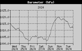
Barometer (air pressure)
Measured in hPa is the weight of the air
that makes up our atmosphere exerts a pressure on the surface of the
earth. This pressure is known as atmospheric pressure. Generally,
the more air above an area, the higher the atmospheric pressure,
this, in turn, means that atmospheric pressure changes with
altitude. For example, atmospheric pressure is greater at sea-level
than on a mountain top. To compensate for this difference and
facilitate comparison between locations with different altitudes,
atmospheric pressure is generally adjusted to the equivalent
sea-level pressure. This adjusted pressure is known as
barometric pressure. In reality, the Davis Vantage Pro Plus measures
atmospheric pressure, but then translates this to barometric
pressure.
Barometric pressure also changes with local weather conditions,
making barometric pressure an extremely important and useful weather
forecasting tool. High pressure zones are usually associated with
fair weather while low pressure zones are generally associated with
poor weather. For forecasting purposes, however, the absolute
barometric pressure value is generally less important than the
change in barometric pressure. In general, rising pressure indicates
improving weather conditions while falling pressure indicates
deteriorating weather conditions
Reception (of Vantage Pro2)
This allows to monitor
the performance on the Davis Vantage Pro2 console of the past 6 hours. It
shows in % how good the reception was between the console and the
remote transmitters with 100% = excellent, 0% = no reception
 Observations
 Observations