| Weather pictures & report of August 18 2011 |
| MCS thunderstorm along thermal trough |
| Synopsis: at 500 hPa, east of a relaxing trough west of the British Isles, our area in a moderate SW'ly flow of warm and humid potentially unstable air. At surface passage of thermal depression with trough enhancing the instability which, additionally provoked by diurnal heating, started from late afternoon onwards with formation of MCS thunderstorms, mainly over central and northeastern parts of Belgium.. Locally in these areas, it lead to severe downbursts with physical and material damage. At the location were all pictures were taken (Steenokkerzeel in central Belgium) thing remained rather modest, Hours of photos in local time (CET). |
 |
|
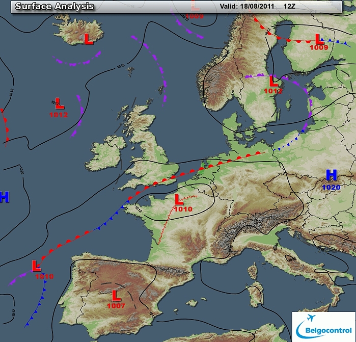
Surface analysis of August 18 2011 at 1400 CET. Related to a thermal
depression over northern France, a thermal trough. Both moved via the
center of Belgium towards the northeast. (Source chart: Belgocontrol)
|
|
Loop of 11 surface analyses of August 18 2011 (of each hour between
1200-2200 CET) with
weather plots showing the slow movement of the thermal depression over
the centre of Belgium. (Source: meteocentre.com)
|
 |
|
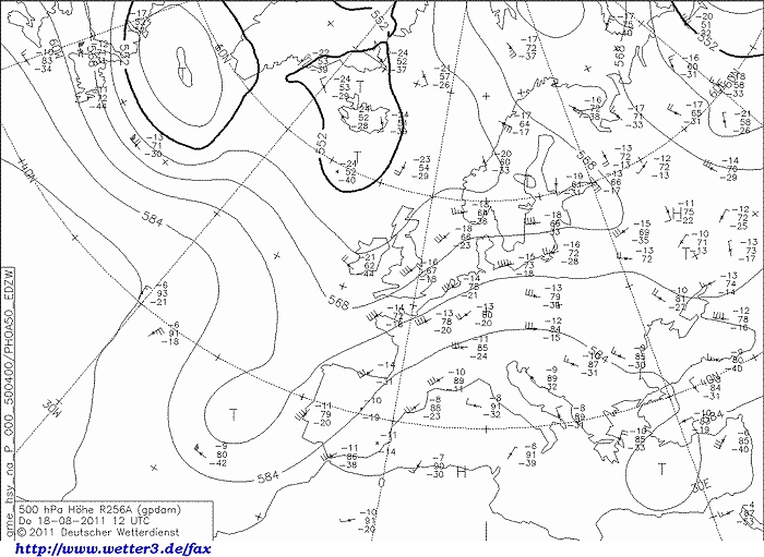
Upper air analysis 500 hPa of August 18 2011 at 1400 CET. A relaxing
upper trough over Ireland as extension of the cold pool over Iceland
with furthermore a filling cut-off low west of the Iberian Peninsula. On
the eastern flank a weak mobile ridge over the continent. It resulted
over our area in a moderate SW'ly flow. (Source chart: DWD via wetter3)
|
 |
|
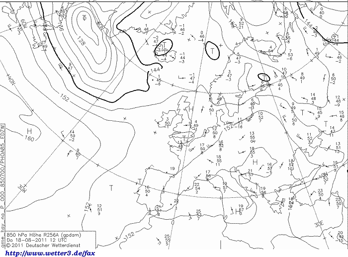
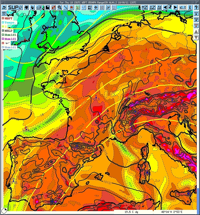
Upper air analysis 850 hPa of August 18 2011 at 1400 CET. Just south of
England a small depression with some cooler air moving eastwards. Overhead a weak SW'ly
flow with still advection of very warm air. (Source chart: DWD via wetter3)
|
 |
|
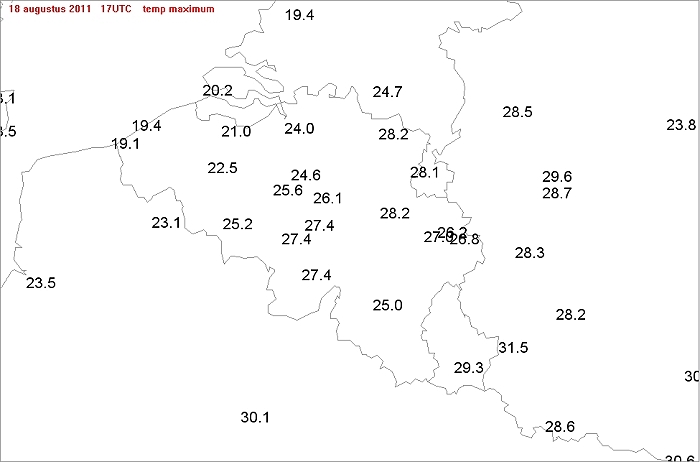
Max temperatures of August 18 2011: no extreme values with the
warmest spots over provinces Limbourg & Liège.
|
 |
|
Upper air analysis of wetbulb temperatures 850 hPa of August 18 2011 at
1700 CET. A so called Spanish Plume of warm and humid air (Tw 18-20°C)
extending from Spain and France via Belgium towards mid Holland. Over Belgium
the highest value was found over province Limbourg with 20°C (Source chart: Belgocontrol)
|
 |
|
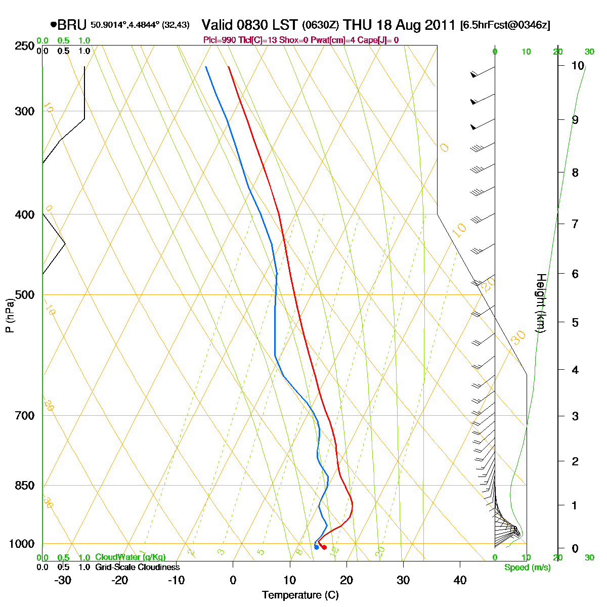
Loop of forecasted soundings for Brussels of August 18 2011 between
0830-2000 CET. Till around 1730 a so called CAP (or inversion) was
present around 3000-5000ft. When due to diurnal heating it was cleared,
deep instability could be released beyond layer 250 hPa (10km). Also
detectable is a pronounced directional windshear in the lowest 3 km
which could trigger supercells. (Source: RASP)
|
|
Another loop of forecasted soundings for a 18 hours period (in steps of
three hours) of Brussels from August 18 2011, 1100 CET onwards. Included
are some thunderstorms indices: surface based CAPE went up little over 2000 J/kg, KI 36, TT 53,
LI -8 = strong convective potential which may lead to frequent
thunderstorms, isolated severe. Directional shear was moderate with 138
m²/s², low level shear was 25 kt, deep layer shear 35 kt. Due to the
rather high CAPE and moderate shear, multicells (eventually MCS) and
supercells (eventually with small tornado's) could be expected. (Source: weatheronline.co.uk)
|
 |
|
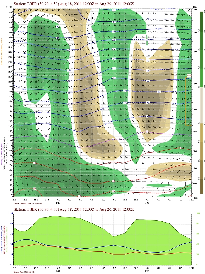
Forecasted vertical profile and surface temperature for Brussels Airport of August 18 from 1400 CET and the following 48 hours. Legend of upper map: green-brown-white
is humidity in steps of 10% with darkest green being 90% or more, wind
in kt, temperatures each 5°C. From the start humid air well towards the
upper levels (200 hPa). Furthermore during the late afternoon of August
18 evidence of a rise of upper air
temperatures with passage thermal trough in warm air. First six hours
also significant shear in direction (and speed). (Source: Belgocontrol)
|
|
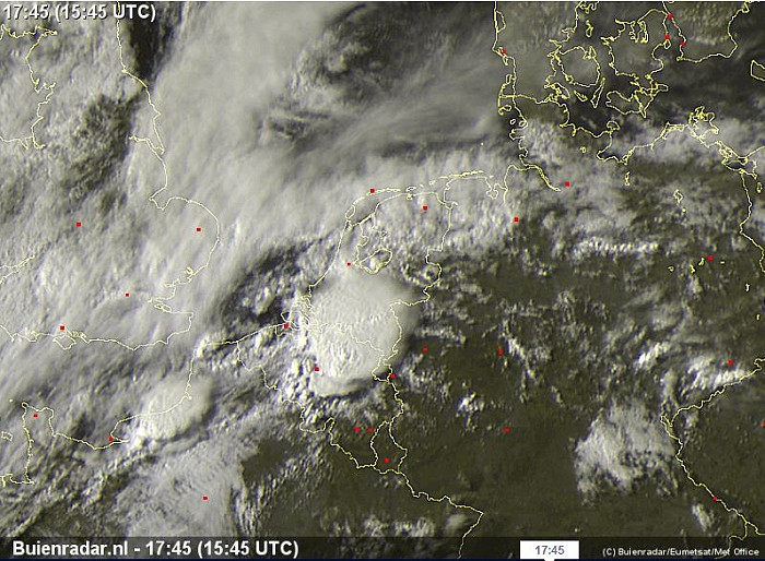
18/08/2011 1500-2045 CET. Satellite loop in the visual channel. An exploding
MCS thunderstorm over central and northeastern parts of Belgium. (Source sat
picture: Eumetsat via Belgocontrol)
|
 |
|
Zoom of a still image of the late afternoon in the visual channel giving a
view of the MCS
with overshooting top over the northeast of Belgium. Further to the
southwest another weaker cell is detectable but it reached Belgium in
its decaying stage. (Source pic: Eumetsat via Buienradar)
|
Radar loop (reflectivity in dBZ) of August 18 2011 between 1545-2200 CET. Over province Hainaut a developing MCS thunderstorm with its mature stage (bow echo) over province Limbourg. Over there a lot of physical damage (5 killed during a pop festival near Hasselt) and also material damage due to downbursts / small tornados. (Source radar picture: Belgocontrol)
|
Corresponding discharges of August 18 2011 between 1430-1815 CET. (Source lightning picture: Blids)
|
 |
|
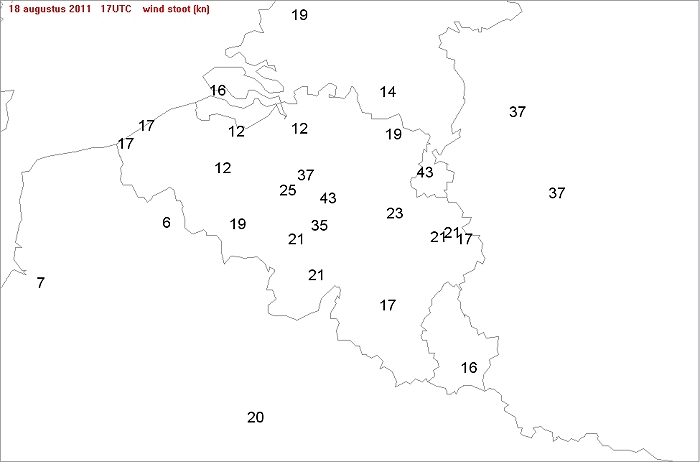
Max gusts (in knot) of August 18 2011 between 1400-2000 CET: Beauvechain
the winner with 43 kt during a (small) downburst, followed by Zaventem
37 kt. Locally over Limbourg (without official recordings), the
winds must have peaked >50 kt.
|
Some metars (hours in UTC). Translation: copy
paste each obs via
metar-decoder Metars of Brussels Airport (EBBR)
Metars of Beauvechain (EBBE) EBBE 181325Z 06007KT 9999 BKN060 26/19 Q1011 BLU BLUEBBE 181425Z 05008KT 9999 FEW055CB SCT120 26/19 Q1010 BLU WHT TEMPO GRNEBBE 181431Z 05008KT 9999 -TS FEW050CB SCT180 26/19 Q1010 BLU WHT TEMPO GRNEBBE 181520Z 07010KT 7000 -TSRA FEW044 SCT050CB BKN065 24/19 Q1008 WHT GRN TEMPO AMBEBBE 181525Z 07010KT 5000 -TSRA FEW044 SCT050CB BKN065 24/19 Q1007 WHT FCST CANCELEBBE 181534Z AUTO 25024G43KT 7000 -SHRA FEW038 SCT045 BKN070 21/20 Q1010 WHTEBBE 181540Z AUTO 29027G43KT 0800 +SHRA VV005 17/17 Q1010 AMBEBBE 181546Z AUTO 31021G34KT 0700 +SHRA VV006 18/18 Q1009 REDEBBE 181552Z AUTO 34016G30KT 3700 +SHRA FEW003 SCT022 BKN039 18/18 Q1010 GRNEBBE 181558Z AUTO 34012KT 9999 SHRA FEW003 SCT025 BKN055 18/18 Q1010 BLUEBBE 181625Z AUTO 06004KT 9999 -SHRA SCT031 BKN039 BKN055 18/17 Q1010 BLUEBBE 181725Z AUTO 33004KT 9000 SHRA FEW009 BKN034 19/19 Q1010 BLU
Metars of Bierset (EBLG) EBLG 181350Z 08006KT 050V110 9999 SCT047 27/18 Q1011 NOSIGEBLG 181420Z 12005KT 070V170 9999 BKN047 28/18 Q1011 NOSIGEBLG 181450Z 19013KT 9999 BKN047 28/18 Q1010 NOSIGEBLG 181520Z 18014KT 9999 BKN047 27/18 Q1010 NOSIGEBLG 181550Z 18014KT 9999 BKN036 26/18 Q1009 NOSIGEBLG 181620Z 22007G18KT 180V350 9999 FEW035CB BKN040 26/19 Q1011 TEMPO 3000 SHRA TSRA SCT030CBEBLG 181650Z 33007KT 290V360 9999 FEW010 SCT035 BKN045 19/17 Q1010 RETSRA TEMPO 3000 SHRA TSRA SCT015CBEBLG 181720Z 28008KT 260V320 1000 R23L/1100VP2000U R23R/1900N R05R/1200VP2000D +TSRA SCT003 SCT015CB BKN023 19/17 Q1010 TEMPO 3000 SHRA TSRA SCT015CBEBLG 181750Z 30004KT 230V040 7000 -TSRA SCT003 SCT019CB BKN035 19/18 Q1011 TEMPO 3000 SHRA TSRA SCT015CBEBLG 181820Z 14004KT 090V230 9999 -SHRA FEW006 SCT019TCU BKN035 19/17 Q1010 RETS TEMPO 3000 SHRA TSRA SCT015CBEBLG 181850Z VRB01KT 9999 FEW015TCU BKN035 20/18 Q1011 TEMPO 3000 SHRA TSRA SCT015CBEBLG 181920Z 16003KT 120V200 6000 FEW015 BKN045 20/19 Q1011 TEMPO 3000 SHRA BKN015EBLG 181950Z 13004KT 4700 BR FEW015 BKN045 20/19 Q1011 TEMPO 3000 SHRA BKN015
Metars of Maastricht (EHBK)
|
 |
|
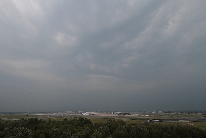
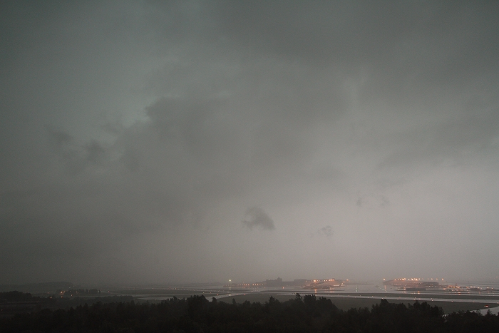
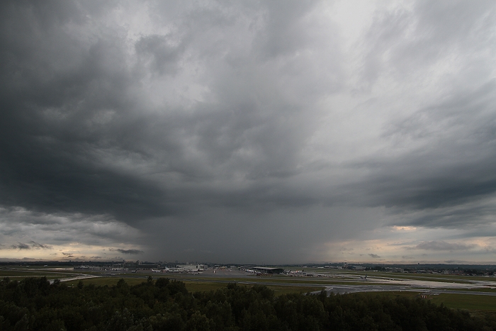
18/08/2011 1645 W. The approach of the developing MCS gave little to
excite about as there seems to be a weakening part going north and
activation part to the south.
|
 |
|
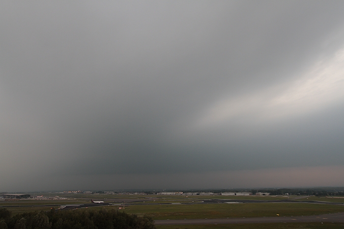
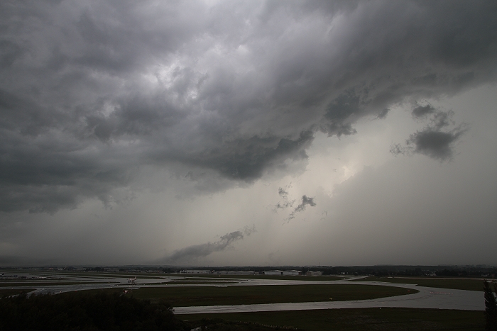
18/08/2011 1656 W. Wind was northeast, the visibility not great and also some
lower clouds began to form without much structure.
|
 |
|
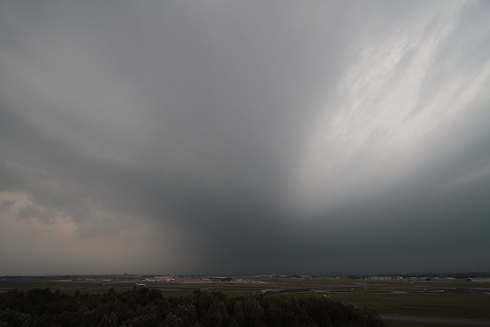
18/08/2011 1659 WNW. On the left hand side the rain shaft was already on
its way.
|
 |
|
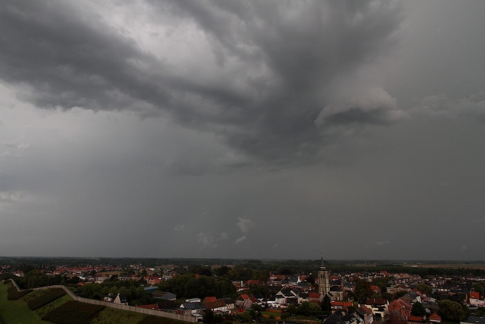
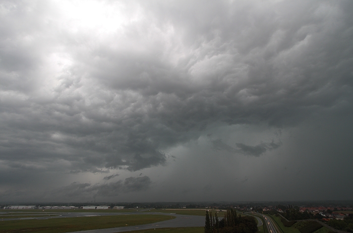
18/08/2011 1714 SW. Bit later followed by quite dark skies with moderate
to heavy falls of rain accompanied by some thunders and gusts of almost 40 kt.
|
 |
|
18/08/2011 1740 ENE. Less than half an hour later it was all over: on
the backside a lot of deep rumbles could be heard. Little later over
Kiewit (near Hasselt) disaster was near by.
|
 |
|
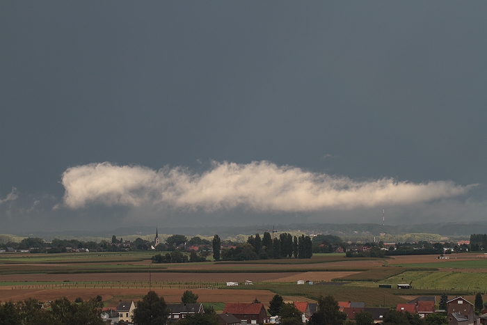
18/08/2011 1751 SE. Contrast of the dark background of the storm against
a freshly formed Stratus fractus receiving some rays of sun.
|
 |
|
18/08/2011 1745 SSW. On the other side also formation of some very low
cloudiness with cumuliform character.
|
 |
|
18/08/2011 1800 W. Meanwhile in the wake of the big storm, formation of
another (smaller) thunderstorm.
|
 |
|
18/08/2011 1825 W. This storm trailed quite long over the north with a
lot of rumbles of thunder and vertical discharges, but none could be
captured on the cams sensor.
|
 |
|
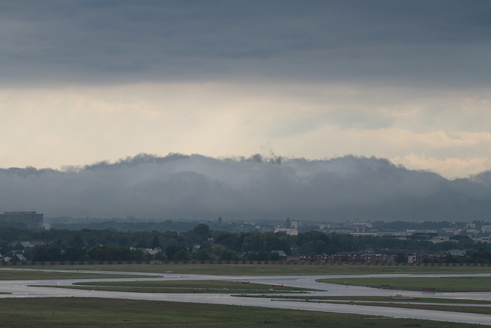
18/08/2011 1839 NNW. Whales mouth effect when passing by.
|
|
This storm was between 1819-1839 also captured on film and speeded up to 20 frames per
second revealing the turbulent character.
|